Buying Chelan County

In most places in Washington State, where a town developed was decided by the people who first inhabited the area or by the European settlers and American pioneers who showed up later.  Seattle owes its map to the Dennys and Mercers. Spokane (originally Spokane Falls) grew up along the Spokane River because early pioneer James Glover saw the falls as a great place for a sawmill. Most towns have a similar story: somebody shows up and says, “let’s settle here” – usually due to proximity to a natural resource like a river, bay, forest or farmland.

This week I learned that early development of Chelan County – and the placement of its county seat, Wenatchee – was decided by a guy who never lived there. The great folks at the Chelan History Museum introduced me to local historian, Rod Molzahn, who told about the decisions that drove early development and governance of the region.

In the late 1800s, railroads were rapidly making their way west – the most significant of which was the Great Northern Railway. Its owner, J.J. Hill, was friends with a Seattle attorney and judge by the name of Thomas Burke (as in the Burke-Gillman Trail in Seattle).  Burke’s good friend, Hill, fed him some very valuable inside information: the route his railroad would take through central Washington.

image

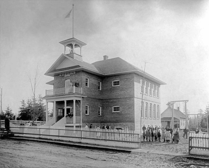
At the time, the town of Wenatchee had already started to take shape. It wasn’t where current downtown Wenatchee is; instead, it was up on the flat. According to Rod, “it had all the things a town needs to thrive – a meat market, hotel and a saloon.”

Burke knew the railroad would cut through the land closer to the Columbia River, well below the already established town. So, like any good insider trader, he quietly bought up 640 acres – at a very low price – along the river. Burke’s Wenatchee Development Company started a campaign to get people to move their businesses from “old town” to “new town.” He hired a couple from Ellensburg to start a newspaper in Wenatchee and act as his propaganda arm. He even sweetened the deal for businesses by offering to move their buildings closer to the river. Eventually, Burke’s scheme started to work. Businesses began to move, people learned about the railroad’s plans, and the value of Burke’s land by the river started to skyrocket.

image

Judge Thomas Burke by cartoonist Edwin F. Brotz

As Wenatchee and surrounding towns such as Cashmere, Chelan, and Stehekin started to thrive, a bill was passed in the state legislature to create Chelan County by carving off pieces of existing Kittitas and Okanogan Counties. This was fought aggressively by Okanogan County, which finally acquiesced in exchange for $77,000 in damages paid to them by the newly formed Chelan County.

The formation of a county required the appointment of county commissioners, the establishment of a county seat and the building of a courthouse. A compromise was struck between the geographically dispersed towns of Cashmere, Chelan and Wenatchee: the state legislature appointed three commissioners – one from each town.

With county commissioner representation decided, the towns couldn’t agree on the placement of the county seat. Chelan argued its nearby hydropower made it a good choice. Wenatchee, of course, had the railroad. Nobody had money to build a courthouse, though. After all, they had a $77,000 debt to pay to Okanogan County.

Guess who had a solution? Good ‘ol Judge Burke just happened to own a 3-story hotel in “new town” Wenatchee that he was willing to deed to the City of Wenatchee – for one dollar – provided that the County Commissioners name Wenatchee as the County Seat. The County Commissioners accepted the offer and to quiet the objections from the Chelan people ,the commissioners appointed Chelan area men to be the county’s first officers, including Sheriff Frank Keller, a rancher from Stehekin – a  tiny town accessible only by boat at the north end of Lake Chelan. “That was a great recipe for rapid response,” joked Rod, as he continued the story.

Because the county commissioners had to travel long distances to get to the county seat, Burke gave them each a room on the third floor  of his hotel – rent free. That’s how Wenatchee became the county seat for Chelan County. Coincidentally, that’s also how Judge Burke’s land increased in value.

image

So far on the ProjectWA road show, I’ve been fortunate to meet with several town leaders who have provided some colorful stories about their respective communities’ history. Early on, natural resources such as rivers, farmland or forests usually determined where a town grew. Later – as Judge Burke demonstrated – the railroad started to play that role.  In the information age, I think the next major economic factor for communities might be interesting stories. If so, Chelan County is going to do pretty well.

If you’re interested in some of those stories, stop by the Chelan Museum – they have quite a few. While you’re there, collect your points for visiting in the Washington State Insider app.

image

Left to right: Chelan Museum Board Member, Linda Martinson; Board Member, Roberta “Peach” Simonds; Museum Manager, Ron McGaughey; Board Member, Mary Sherer

The Enloe Dam Challenge

“Let’s just leave the car here and walk down,” Kristine and I said in unison as our little Ford Fiesta bottomed out on the steep, rocky road. We were intent on getting to the abandoned dam and waterfall below, but we were also intent on getting to Republic that evening in one piece. So we walked, well, scampered down to the river.

image

I’d been wanting to check out Enloe Dam ever since Ava gave a presentation on this endangered property back in February. When I found out this was named one of the 2016 Most Endangered Historic Properties by the Washington Trust for Historic Preservation, I insisted that we add it to our summer road trip itinerary. After hiking down to see it, I’m glad I did.

Henry and Ruby beat Kristine and me to the bottom. As I approached the river, I saw Ruby scaling the chain link fence at the river’s edge. I heard myself scream, “Ruby, haven’t you ever seen the Niagara Falls scene in Superman II!”

image

The Similkameen River falls are stunning. The mist rising up from the rushing water was very welcome, given it had turned into a warm day. We hiked down river to the point right across from the powerhouse. The building is in pretty bad shape, but I found myself imagining what could go on there if somebody restored it. Given its perch on the river and view of the falls upstream, it’d make a pretty spectacular restaurant. It would have been a great place to work 100 years ago, before Bonneville Power made the dam unnecessary.

image

After snapping some photos to document our accomplishment, we began the long walk back up the hill. The Fiesta made it out, but I’d recommend 4-wheel-drive to anybody planning on checking out Enloe Dam.

image

The Birthplace of Smokejumping

Six weeks ago, Andrew Thibodeau stood at a doorway. He slapped both sides of the door frame and then grabbed a pole to his right. A guy crouching behind him yelled “Get ready!” A moment later, that same guy slapped the back of Andrew’s leg. That was his signal to jump through the door. He was 1500 feet above a forest.

“I was doing fine until I grabbed that pole,” said Andrew, telling the story of his first parachute jump during a 6-week training course at North Cascades Smokejumper Base just outside of Twisp, Washington. Today, the ProjectWA team was lucky enough to get a history lesson and tour from Andrew on his first official day as a rookie smokejumper. After a rigorous training, he joins an elite group of 25 other parachuting firefighters stationed at an airfield situated in the Cascade foothills.

image

A CASA C-212 Aviocar sits ready to fly within 5 minutes of the alarm.

The Methow Valley became the birthplace of smokejumping in 1939, when fire guards, Francis Lufkin and George Honey, made 58 experimental parachute jumps to determine under what conditions firefighters could safely land in inaccessible mountainous areas to fight wildfires. Lufkin, who had spent several years dropping supplies by parachute into wilderness fire areas, said, “If we can deliver boxes via parachute, why can’t we also deliver people?” Today, smokejumping is the most cost-effective wildfire fighting method employed in the U.S. More than 400 smokejumpers are stationed at nine main bases and dozens of satellite bases in the western U.S.

image

Francis Lufkin, ready for his first experimental jump in 1939.

The critical role smokejumpers play in fighting wildfires has received more attention in recent years, as forest fires have increased in frequency and intensity. The 2015 Okanogan Complex fire was the largest in Washington State history.

Most people don’t realize the other critical contribution smokejumping has made to history. Until 1939, people didn’t voluntarily jump out of airplanes. Parachutes were for in-air emergencies, usually at high altitudes. Francis Lufkin’s new firefighting method demonstrated the feasibility of parachuting from low altitudes, with extreme precision, into a hostile environment.

In 1940, U.S. Army Major General, William C. Lee, visited the North Cascades Smokejumper Base to better understand how this new skill could be used for military purposes. Later that year, Lee became the first commander of a new parachute school at Georgia’s Fort Benning, which became the U.S. Airborne Command. Paratrooping was born. Four years later, 13,000 American paratroopers made night drops during D-Day, which turned the tide of World War II.

After taking Andrew’s tour, I understand the similarities between preparing for war and training to be a smokejumper. As if parachuting and firefighting aren’t hard enough, smokejumpers must also be expert rappellers and tree climbers. Though landing in meadows is the goal, sometimes they land in trees; so smokejumpers have to be in great physical shape to first get themselves untangled and then make their way to the ground, sometimes 40 feet below – all while wearing Kevlar jump suits and a 100 pounds of gear. They can’t just leave their chutes in the tree, which means climbing back up to retrieve them.

Once on the ground, parachuters turn into fire fighters and survivalists. They bring supplies that allow them to fight fires for as long as three days: axes, chain saws, shovels, food and drinking water. Everything gets dropped in boxes at the same time as the smokejumpers. The firefighting is done by digging 18-inch-wide paths, creating lines around a fire area – effectively starving the fire of the vegetation that fuels it.  After a few days of nonstop work, the crew has to hike to the nearest accessible road to be picked up.

image

The job doesn’t end when smokejumpers get back to base. The work simply transitions into other tasks so that the crew is prepared for the next jump: sewing up ripped chutes and suits, packing boxes with gear, food and water; and packing parachutes. All so that, within 2 minutes of the alarm, smokejumpers are suited up and on the plane. Then there’s all the other chores associated with day-to-day living.

Smokejumpers are self-sufficient on – and off – the fire line.  They cook for themselves, tend their own garden and mow the lawn. And they sew.  Every smokejumper knows how to operate a sewing machine – a tool just as critical to the whole operation as axes, shovels and airplanes.  With an average of 45 jumps per year (the record is 1066 in 1970), chutes and suits get torn and have to be immediately, expertly mended. I was surprised to learn that all the gear – shirts, suits, pants, and chutes – is made by smokejumpers right there on the base.

image

One of the most important smokejumping tools.

When they’re not jumping out of planes, firefighting or sewing, smokejumpers are staying fit. They devote at least an hour and a half to exercise every day. Their 6-week training course is what I’d imagine boot camp to be – probably harder. Andrew showed us the tower from which smokejumpers practice their “PLFs” (Parachute Landing Falls). “A lot of misery went down here,” Andrew mused as he gazed up at the 40-foot structure, which he referred to as “Torture Tower.”

image

Andrew Thibodeau, Rookie Smokejumper in front of the “Torture Tower.”

There were many things that impressed me about smokejumpers. What struck me most is their culture of complete trust and reliance on each other. Every smokejumper knows how to do every job on the base – from sewing and packing chutes to being the “JIC” (Jumper in Charge). It’s all about efficiency. When every second matters, there’s no time for figuring out who within a jump crew has seniority. Whoever is in the seat closest to the airplane door automatically plays the role of JIC – whether they are an 18-year veteran, like Kathlyn Russel, or a brand new rookie, like Andrew.

So who is in charge of the smokejumpers, overall? They are part of the U.S. Forest Service, which is run by the Department of Agriculture. Though they are federally funded, there are gaps.  The smokejumpers sell souvenirs to raise money for the Fallen Firefighters Fund (I bought myself a cool smokejumper coffee mug).

image

If you are anywhere near the Methow Valley, the North Cascades Smokejumper Base is a must stop.  You’ll get one of the best free tours around, learn some important history that’s relevant to all of us, and get a chance to thank a group of individuals that put their lives on the line to keep us all safe. Before you go, download the Washington State Insider app so you can get your points for visiting.

image

As of June 23, 2016, the jump counter is still set at 0. The average number of jumps per year is 45.

Pybus Market: From Steel Foundry to Gathering Place

According to his April 5, 1961 obituary in the Wenatchee Daily World, Elias “Tom” Pybus’s first impression of Wenatchee was “of board sidewalks, dusty streets and a stifling hotel.” He used to say: “the whole valley seemed like a furnace.” Two decades later, the U.K. immigrant blacksmith constructed his own furnace along the banks of the Columbia River in Wenatchee, which grew into one of the region’s most successful steel foundries. E.T. Pybus Steel Company started out making wagon parts and auto springs, and eventually provided steel for the construction of the Grand Coulee Dam, Hanford and WWII ships for the U.S. Navy and Air Force. By the time he died in 1961, E.T. Pybus’s contribution to economic growth in Chelan County rivaled that of the apple industry, for which the area is mostly known, historically.

image

Over the years, the early pioneer’s steel company was eventually split into separate companies, and the large warehouse that used to house Pybus’s foundry became the home of pigeons floating in off the Columbia. Despite the impact E.T. Pybus had made on Wenatchee in the 20th century, later generations had no idea what that building on the corner of Orondo Avenue and Worthen Street represented.

“As a kid growing up in Wenatchee, I had no idea this building even existed,” said Caitlin Gillespie, Operations Administrator for Pybus Market, as she gave me a tour of one of the coolest structures in Wenatchee.

image

The Pybus building emerged from obscurity when, in 2012, Mike and JoAnn Walker established the Pybus Market Charitable Foundation to work in collaboration with the Port of Chelan County to refurbish the 25,000-square-foot space. The year-round Market was opened in May 2013 and now houses some of the best businesses that Wenatchee has to offer: a produce stand, florist, brewery, wine tasting room, cheese shop, restaurants, butcher and more.

image

On the recommendation of Cascade Loop Association Director, Annette Pitts, I popped in on Steve Robinson, the Executive Director for the Pybus Market Charitable Foundation. Steve, along with Caitlin Gillespie, manages day-to-day operations and marketing for the Pybus Market.  After they showed me the space, my assessment is that their most important marketing job is to simply get people in the door. The building does the rest.

The Pybus Market has a very inviting vibe. After my official tour, I hung out for another hour, drinking coffee and writing while periodically lifting my head to people watch. The Market is nicely situated along the Columbia River between downtown Wenatchee and the Apple Capital Loop Trail that runs along the river. It’s a natural spot for people to congregate – visitors and tourists alike. The design of the Market was inspired by the Ferry Building Marketplace in San Francisco. When I saw the Pybus Market from the outside, it immediately reminded me of the indoor market in San Francisco.

image

One of things that gives the Pybus Market its cool vibe is the live music.

Even better than the architecture and location are the extremely friendly local merchants. The Pybus Market has a concentration of high quality regional businesses – from locally brewed beer to produce to local meat. On my way out, I bought some local beef from Mike’s Meats to take back to this week’s ProjectWA headquarters in Lake Chelan.

image

Mike’s Meats at Pybus Market

A big focus for ProjectWA so far has been preservation of historic properties, so I asked Steve about the impact the restoration of the Pybus Market has had on the community. “When cities develop waterfront, good things happen,” Steve said.  “It has put [Wenatchee] on the map.” The Market has created more than 100 local jobs, and the rest of the waterfront is starting to redevelop. A new hotel is going in down the street, which Steve suggests probably would not have be happening without the presence of Pybus Market.

After more than three years of year-round operation, the Market has evolved into a community center. “People congregate here,” said Steve. It’s no wonder, then, that the Pybus Market was named “Best Place to take an Out-of-Town Guest” by the Wenatchee Business Journal Readers’ Choice Awards.

image

The creation and growing popularity of the Pybus Market has coincided with the emergence of an evolved identity for Wenatchee – from a small town known almost singularly for its apples, to “an outdoor mecca” known for skiing, biking, and countless other types of recreation. E.T. Pybus would be proud.

If you want to see the intersection of Wenatchee’s history and future, I strongly recommend you check out Pybus Market. If you download the Washington State Insider app, remember to collect your points for visiting.

image

ProjectWA Students Become the Teachers

Yes, ProjectWA is about connecting history and place. For five Lopez Island Middle School students, their teacher, and me, it’s been about so much more. Fundamentally, ProjectWA has been about connecting people. Anna, Ava, Mallory, Sonnette and Shayna have made many connections this semester: with historical figures, with preservation advocates, and with each other. Today, they connected with the 4th Grade Lopez Elementary Social Studies class.

As their final ProjectWA assignment, our students were to write a blog post on one of this year’s Most Endangered Historic Properties. They learned quite a bit in the process: different approaches to research, how to interview an expert, and how to write a compelling call-to-action. The final articles are great. Mr. Rovente and I wanted the kids to go a step further – by turning those written works into presentations.  Lori Swanson, the Lopez Island Elementary social studies teacher, agreed to provide the audience for those presentations: twenty fourth-graders, whose final topic of the year is Washington State History.

image

It was gratifying to watch the ProjectWA students become the teachers. The fourth graders were engaged throughout, and their questions for the middle schoolers were great. After every presentation, the younger kids got a chance to connect history and place the old-fashion way – with stickers and laminated maps of Washington State. Apps are cool, but stickers make everything more fun.

image

With the student presentations complete, this semester’s ProjectWA class has come to an end. Now it’s time for me to go to school. For the next two months, my family and I will travel all around Washington State, checking out as many of the students’ app locations as possible. We’re also in search of other historic places, so we’re inviting people to send us suggested locations for us to research and then incorporate into the Washington State Insider app.

I’m incredibly proud of what Anna, Ava, Mallory, Shayna and Sonnette accomplished this semester. I’d like to thank them – and their awesome teacher, Anthony Rovente, for taking on something that had never been done before. We all learned a ton. I know there’s a lot more to learn.

image

New Heights for Providence Heights?

By Shayna G., Lopez Island Middle School Student

The 1960s were an important time in history for both women and the Catholic Church. Women were finally beginning to gain more rights and opportunities when it came to their professions. Up until then, women had very few choices of professions to choose from, where as men had seemingly endless choices.

Women of the Catholic Church had even fewer choices than their secular counterparts due to their education. In high school, young women training to be nuns learned about the Catholic Church along with their regular high school curriculum. After graduation, these nuns would only learn about the Catholic Church. In the 1950s and 1960s, this began to change as the Church came to the realization that their nuns in training needed more knowledge than what they learned about Catholicism.

The Sister Foundation came to the conclusion that one solution to this problem would be to build and open a college where women studying to be nuns could take regular college classes such as chemistry, math, and literacy, in addition to their religious studies. The college they opened was called as Providence Heights College in Issaquah, WA.

Providence Heights Campus is located on a beautiful plateau in Issaquah, surrounded by farmland. The Sister Foundation spent 6 million dollars to build the entire campus before is was opened in 1961. They spent extra money for quality building materials and design.

Perhaps the most expensive part of the campus is the center cathedral; which has fourteen 33-foot-tall stained glass windows that weigh approximately one ton each. The windows were the work of Gabriel Lore, a world renowned French stained glass artist. Lore had a very unique art style because he crafted one-inch-thick glass chunks into beautiful, modern designs – instead of imitating classic stained glass windows. Gabriel Lore passed away 20 years ago. There will never again be art pieces exactly like these windows.

After opening, Providence Heights College thrived for about five years. Thousands of women were registering for the college. This began to change as women started to have more rights and job opportunities that they were previously denied. Some women felt they didn’t need to become nuns as other professions became available to them. As more and more women came to this realization, fewer began to sign up for Providence Heights College. Only eight years after the college’s opening, there were so few women attending the college that it didn’t make economic sense to keep the college open. It was shut down in 1969.

Since its closing, the college has remained mostly vacant. It briefly served as an Issaquah preschool and a meeting place for local organizations. Although the campus is currently not being used, many residents of Issaquah believe that the campus would serve wonderfully as either a community center, a school, or a meeting place for different organizations. Because the Sister Foundation spent the extra money on quality building materials, the campus is still intact and in great condition. In fact, the campus is in such great condition that Steve Thues, outreach manager of the Sammamish Heritage Society says: “It’s almost a turn-key school as it is. You could probably go in and start teaching classes here this week.”

Despite the fact that the campus is in such great condition and has never been remodeled, making it a great example of 1960s architecture, there has still been plans filed with the city of Issaquah for the entire campus to be leveled and replaced with 133 modern homes. If these plans come to fruition, not only will a historic, non replaceable cathedral be destroyed, but also part of Issaquah’s history will be lost forever.

Although there are organizations working to have the campus demolished, there are also many people working to preserve the campus. Local city residents and preservation groups such as the Washington Trust for Historic Preservation and the Sammamish Heritage Society, are working to save the historic campus.

An example of a local Issaquah resident working to save the campus is Ella Moore. Moore is the president of the Sammamish Heritage Society and has been a Sammamish resident for fifty years. “This is too unique to be destroyed,” she said. “We need those things up here because it’s development crazy and the children and all peoples need to know that there was history here on the plateau; and this is a prime example.”

Providence Heights Campus represents an important time in history for both women and the Catholic Church. Although the campus is not even a century old, it’s still an important historic site in Washington  State, and it contains an irreplaceable center cathedral with the work of a world famous stained glass artist. If this whole campus is leveled all these things will be lost.

The Washington Trust for Historic Preservation website says that if you want to help take part in the potential preservation of Providence Heights Campus, you can contact the City of Issaquah and ask that city officials require the developer to conduct an Environmental Impact Statement (EIS) for the project. If required, an EIS would compel the developer to consider alternatives to demolition and would provide critical time to identify potential preservation-friendly uses for the site.

To learn more go to http://preservewa.org/news134.aspx or download the Washington State Insider app when it launches in mid-June.


Stone Houses

By Sonnette R., Lopez Island Middle School Student

During the Great Depression, Clint Dobson, a businessman in LaCrosse, Washington, built several houses out of basalt stone because he didn’t have enough money for other materials. The stone houses were built between 1934 and 1936 from rocks out of the fields in Lacrosse. These buildings are very unique for this time period, and they attract many tourists and photographers.

rock-houses-550

The basalt stones in the Lacrosse fields were created by the repeated flooding from Lake Missoula over thousands of years. This shaped the area of Lacrosse, including nearby Palouse Falls.

Palouse Falls

According to Lacrosse local, Peggy Bryan, “the unique geological events of the Missoula floods combined with the unique construction of these depression-era basalt stone structures provide an important and historically significant preservation opportunity that is well worth pursuing.” Protecting this historical monument would provide “a great educational opportunity.”

The LaCrosse community’s goal is to have a Missoula Floods/Ice Age museum in the old gas station that was made out of stone. According to Bryan, this would “add value to our community, both economically and culturally.”

LaCrosse Stone Station

LaCrosse Community Pride is working with the WSU School of Design and Construction’s Rural Communities Design Initiative on this project. Community input was facilitated and conceptual designs have been developed for the incorporation of a visitor center in the museum. There are five other rock structures on the property that could provide many opportunities, including artist retreats, a farming museum, local gift shops, tasting rooms, and bed and breakfasts, among others.

Originally, the stone houses were used as rental units by local farmhands, workers, and railroad crews. Clint Dobson operated the service station and repair shop for many years until Hank Pile took over, operating the station and houses until the 1960s.

Today two houses, three cabins, and the service station are still standing. The buildings are important because they bring visitors to the area. Lacrosse Community Pride is focused on preventing these structures from being torn down.

To learn more about the LaCrosse Stone Houses, find them in the Washington State Insider app (available mid-June 2016). When you visit, you’ll earn points that will get you a discount at the Washington State History Museum in Tacoma.


Saving Enloe Dam

By Ava F., Lopez Island Middle School Student

Last year my dad and I took a trip to Eastern Washington on vacation. One stop on our trip was a waterfall on the Similkameen River near the town of Oroville. While walking to the falls, we passed several abandoned buildings along the river’s edge. I was curious about these buildings, and this year in Northwest History class I was able to get some answers about their history.  What I have learned is that the buildings I passed that day are what remains of the Enloe Dam, a dam that provided power to the surrounding community in the early 1900s. I also learned that the Enloe Dam is one of the Most Endangered Historic Properties in Washington State.

Similkameen River

Enloe Dam is a small rundown power plant placed next to a beautiful waterfall. The Similkameen River provided power to the area starting in 1907. The powerhouse we know today as Enloe Dam was built using local brick in the 1920s by Eugene Enloe. The town of  Oroville relied on Enloe for its power and electricity until the 1950s, when Bonneville Power started provided cheaper and more efficient electricity to the area.

The Enloe Dam has seen better days. Not many people can see what it was once used for, as it is now rundown and very much abandoned. The building itself was very sturdy until vandals started to destroy it.

Enloe Dam Powerhouse

The history of this Dam was built by the men and women who worked there. Without them there would be no Enloe Dam, and the people in the surrounding towns would not have power. This Dam faces the terrifying truth of extinction. With Enloe being so remote, there does not seem like there could be a lot of use for the building. Some people think this could be turned into a museum or even a rest area for travelers coming through the area.

The communities surrounding Enloe Dam and the Washington Trust for Historic Preservation are trying to save it. I encourage you to visit the Dam. You can find it in the Washington State Insider app (available mid-June).

Enloe Dam

Relocating the Dvorak Barn

By Mallory Q., Lopez Island Middle School Student

The Dvorak Barn on 22274 Russell Rd in Kent, WA represents the area’s agricultural heritage. It is slated to be torn down to make way for a levee that will be going through the farm on which it sits. I hate this. Do you know why I hate this? I hate this because the Dvorak barn has an intriguing history.

Dvorak Barn - from front

The Dvorak Barn on 22274 Russell Rd in Kent, WA

One of the earliest settlers of the Kent Valley, David A. Neely, was the recipient of a Homestead Land Grant for the area that became a 320-acre farm. Built in 1906, the Neely’s home preceded the barn, which was built in 1925. This is interesting because the house acted as the first post office for the first postmaster in Kent. Not only did they deliver the mail, they helped Kent become the lettuce capital of Washington State. Pretty cool, huh?

The farm flourished due to their lead in hops, corn, lettuce and onions – until eventually modern times caught up with them. The Neelys were doing well with their farm and post office, until the postmaster, David A. Neely, passed away. He passed his farm onto one of his eight children, James Neely.

2000_005HopFarm

A hops farming family in early Kent

Interstate 5 eventually had to be built. As it expanded, it ran through Kent Valley, eliminating a lot of the farming land in the area. The barn closed because of the new highway. The result: an awesome little bit of history fell into disrepair.  Now with the levee needing to run through the farm, all buildings on that stretch of land will need to be torn down or moved.

Over time, all the farms in the Kent Valley have disappeared as warehouses have sprung up over the past 50 years. This started with the construction of the Boeing Space Center in the 60s. Within the past few months, Amazon.com opened a massive distribution center. Kent, once known for agriculture, has become the 4th-largest warehouse distribution center in the United States.

Amazon Distribution Center - Kent

Amazon’s new Kent distribution warehouse, less than a half-mile away from the Dvorak Barn

As a former 4H-er I am proud of the farm lands in Washington State. All Washingtonians are proud of our farm lands. It’s a big disappointment to all of the local farm owners to see this barn be condemned.

One way of saving the barn would be to move it. Sharon Bersaas, long-time Kent resident, has advocated for this option in order to preserve this legacy. “Our history has a wonderful story and using the Barn for an interpretive center we would be able to tell our story to future generations,” said Bersaas.

Bersaas and others have lobbied to get the barn moved to a preserved property, but the isolated area – along with the lack of funding – has made this venture a nonstarter.

One way to move the barn would be through crowd-sourced fundraisers such as gofundme, kickstarter or indiegogo. These could help raise funds to relocate the barn. The Greater Kent Historical Society’s Facebook page has a lot of information about the barn.  It could be used to make a Kent Historical Museum or an art gallery, or something along those lines. I think it would be neat if they were to make it into a restaurant. It would be awesome if they were to put up pictures of the barn, Kent and the community back in the 1920s, up on the walls around in the barn. Not only would you be eating, you would also be learning about some of the history of Kent, which, in my opinion, is pretty dang cool.

I hope that this story is meaningful to you and you want to help raise funds for the barn. Help support awareness by downloading the Washington State Insider App (available mid-June) and visiting the Dvorak Barn in Kent!

Dvorak Barn - from back

The back of the Dvorak Barn

Woodinville Schoolhouse’s Last Lesson: How to Preserve our Past

By Anna V., Lopez Island Middle School Student

Woodinville Schoolhouse is one of the last remaining historic buildings in Woodinville, WA. Woodinville was one of the first towns to be settled across Lake Washington from Seattle in the 1880s. The schoolhouse is on the corner of 133rd Ave NE and NE 175th Street, near Woodinville City Hall and the sports fields – once the center of activity of Woodinville. It has been vacant for sixteen years, and minimal effort has been made to keep it maintained. The building now is starting to get cracks on the walls. There are plants growing up against the walls as well. Without any rehabilitation, the building will crumble. Once this building is destroyed no one can recover all the history that it represents.

Woodinville Schoolhouse front

Originally a wooden structure, the Woodinville Schoolhouse is actually a compilation of three  building projects. It now stands as an example of  1930s architecture and the New Deal program,  Work Projects Administration (WPA).

p071b-Woodin School

The Schoolhouse served the kids of Woodinville for almost a century until it closed down in the 1970s. By that time, the Woodinville population had outgrown the Schoolhouse, so it was rented out to community groups. It was later used for city hall, but the City of Woodinville closed it down after the Nisqually Earthquake made the building unsafe to occupy. The Woodinville Schoolhouse now faces “demolition by neglect.”

Woodinville leaders disagree on the future of the Schoolhouse. Many people want to remodel it. Others, such as members of the City Council, want to tear down the building to make room for a parking garage. The Woodinville Heritage Society’s mission is to preserve and perpetuate the history of the greater Woodinville area.  Rick  Chatterton, Heritage Society Board President, would like to see the Schoolhouse once again be a gathering place for the community. Chatterton and the Heritage Society are talking to the State of Washington to confirm that the building is on the National Historic Landmark list. If it is on the list, it will be much harder, if not impossible, for the City Council to have the building torn down.

Chatterton feels that it is important to preserve the Schoolhouse. “It is more than just bricks and mortar; it tells the story of our community,” he said. “It represents the importance of education, community activities and how we have grown over the last century. To lose it would mean losing 120 years of history and robbing future generations of our unique story.”

Rick Chatterton

Rick Chatterton, Board President, Woodinville Heritage Society

The Woodinville Heritage Society has been driving the efforts to preserve the Woodinville Schoolhouse since 2004.  Over the years there has been support from some members of the City Council and various private building interests.  In 2001 the City, through the Woodinville Landmarks Commission and King County Landmarks and Heritage Commission, designated the building as a City of Woodinville Landmark. Recently, the Washington Trust for Historic Preservation placed the Schoolhouse on its Most Endangered Properties List.

The history and the value of the Schoolhouse will never be the same if people want to ruin what is left. This building has been in Woodinville for 120 years. Destroying it would be a terrible thing.  As Chatterton explains, “Once a historic building like the Woodinville Schoolhouse is destroyed, it is gone forever.”

If you would like more information you can download the Washington State Insider app (launching mid-June 2016) and earn points for visiting the Woodinville Schoolhouse. Those points can be redeemed for discounted entry to the Washington State History Museum in Tacoma. You should also check out Woodinville Heritage Society’s website: www.WoodinvilleHeritage.org

p073b-Wd School & Gym 1950

Woodinville School students, circa 1950